Gunter’s Chain**
March 23
1852 Tuesday. Alson and wife dined here and spent
the afternoon at Edwins He has been running
out lines for Edwin & Melvin Randall Orinthia
went home with them. Was at tea in Edwins
& this evening with Augusta at Augustus’
Augustus has gone to New York. Susan is staying
there to night went just after dinner. Oliver & wife
went to Boston this morning Rained untill early night.
The Gilmore clan was moving around today. Evelina’s nephew, Alson “Augustus” Gilmore, was headed for New York City on business for his boot company or the Ames shovels, or both. Evelina’s brother (and Augustus’s father), Alson Gilmore, and his wife, Henrietta Williams Gilmore, had midday dinner at the Ames house. Alson was in the village helping another son, Edwin Williams Gilmore, and an Easton man, Melvin Randall, run out lines.
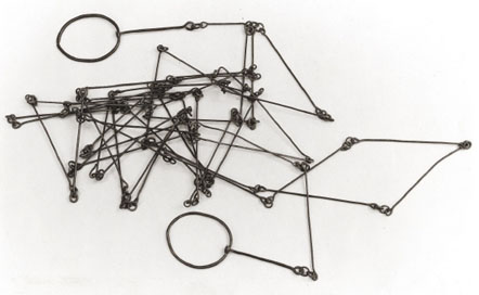
The phrase “running out lines” is open to interpretation (ice fishing is a possibility!), but the most likely meaning is that ground was being measured, perhaps for the new factory buildings soon to be built. A running measure is the cumulative distance in a straight line from a fixed point. The standard instrument used to get a running measure, at least in the 18th and 19th centuries, was a Gunter’s chain. It was used in conjunction with a compass and a transit (for establishing straight lines) to measure ground.
Invented by an English clergyman and mathematician, Edmund Gunter, around 1620, the Gunter’s chain “played a primary role in mapping out America.”** The Army Corps of Engineers would have owned such chains in bulk. The chain’s 100 lines measure 4 poles, or 66 feet, or 22 yards, depending on how you care to count it. Eighty chains equal one mile.
The Gunter’s chain, however, helpful as it was, was apt to be hand-made and thus subject to variation. It was eventually replaced by the more accurate surveyor’s tape.
By the way, for those readers who follow the game (or watch Downton Abbey), the length of a cricket pitch is exactly one chain.
*Thank you, Frank Mennino, for your assistance on today’s blog.
**Image from Colonial Williamsburg, courtesy of http://www.history.org

Thanks for the technical information. It is very interesting. (all that and Downton Abbey too!)
Gunter’s chain!! Hadn’t heard that name before. But when I had a survey office, we came across lots of old survey distances described in chains and links. Talking about Downton Abbey (of course! Who doesn’t watch it?) some of the best actresses (one, my favorite, the littlest kitchen girl) is in the new Cinderella (worth seeing, not animated).
Thanks, Caroline. When – and where – did you have a survey office?
Upstate NY in the mid-eighties. Properties had been lying dormant (unable to sell) for about 12 years and then suddenly that little valley was discovered and people came over the mountain from VT and up the river from NYC and properties began moving, except they couldn’t get bank loans because they couldn’t get a survey because there were no surveyors. I happened to know a surveyor out in the western part of the State and, with my architectural and construction experience, I figured I could run a survey office if he would come weekly and sign off on the surveys. And so for a 4 year period, that is what we did until all the survey needs got caught up.
So interesting – thanks!
Sorry to respond late here, but I had to prepare and deliver a program on Sharon and Mass. in the 1600’s which has now been done. An important part of that presentation had to do with the establishment of the Colony Line in 1639 between the Mass. Bay Colony to the North and Plymouth Colony to the South. Below is an excerpt from notations on the Map of the 25 Divisions, which covers the land just north of Oliver country, in fact half of his Great Pond, (now Ames-Long Pond) is identified on this early map as Trout Brook and Trout Brook Meadow. As I’m sure I have mentioned earlier, my back yard goes down to this pond. Stoughton peope had dammed it up to a small pond in the 1700’s and Oliver, with help from son Oakes, many workers, and a fair amount of rum (this was before the era of Ames temperance 😉 added a new dam and a hammer shop circa 1825. The reference to Gunter’s chains is at the end:
A MAP or PLOT of the Twentyfive Divisions of Land (so called because a Single Division or each Proprietors Proportional part which was determined before the Quantity of Land to be laid out was known, doubled Twentyfive times to take up all the Land that was to be laid out) late in ye Township of Dorchester and now in the Township of Stoughton, it being part of that Land commonly called Dorchester New Grant beyond the Blew-hills: Ordered by the Proprietors of the Common Lands in Dorchester in ye Year of Our Lord 1713 to be laid out: And in ye Year 1714 a Committee of Twelve Men , viz. Mr. Samuel Capen, Capt. Sam.l Paul, Lieut. Sam.l Clap, Mr. Ralph Pope, Mr. John Tolman, Capt. Roger Billing, Mr. Jeremiah Wales, Mr. Thomas Lion, Mr. Philip Withington, Mr. Edward Foster, Mr. Nash Butt, Mr. Eben.r Mausley were chosen to perform and to work: And in ye Year 1715 Mr. John Robinson was chosen in ye room of Mr. Foster who refused : and also James Blake Jun.r. was added to ye Committee. In the beginning of ye Year 1716 the Com.tee began the s.d work Three of them at a time changing by Course generally every Week, first taking the Survey of the whole, and then Proceeded in ye Spring & Fall Seasons to lay out the Lots, which were all (or near all) finished by ye end of the Year 1717. In the Year 1718 the Additional Lots to ye Twentyfive Divisions (so called) being Granted by the Proprietors and ye same Com.tee Appointed to lay them out they proceeded in ye work, and finished all ye Lots that are contained in this Plot in ye Year of 1720.
This Plot was made by the Order of the Proprietors Wrought by the Scale of 20 of Gunters Chains or 80 Rods to an Inch. By James Blake, Jun.r Surveyor … Finished May 8th, 1730 …
Fascinating, Dwight – thanks!